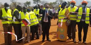
Background Information
District Leadership
District Overview
  Education
  Health
  Agriculture
Opportunities
  Potential
  Facilities
  Comparative advantage
  Statistics
  Infrastructure
  Economic activities
District activities
NGOs in Kitgum
Commodity Supply & Prices
District Contacts
Feedback


Kitgum district is in the northern part of Uganda. It is located between Longitude 320E, and 340E, Latitude 020N and 040 N. It is bordered by the Republic of Sudan in the North, Kotido District in the East, Pader District in the South and Gulu District in the Northwest.
Click to view District Map

Neighbours

Kitgum district is located in northern Uganda and borders the Republic of the Sudan to the north, Kotido district to the east, Pader district in the south and Gulu district in the southwest. The Town Council is 452 kilometers north of the Ugandan capital Kampala.

Click for more.

Kitgum At a Glance

Weather

District has dry and rainy seasons. The district receives average annual rainfall of 1330mm. Rain starts in late March or early April and ends in November. Rainfall is bimodal with peaks in April and August. It is dry-hot and windy from December to mid March. The average monthly maximum temperature is 270 c and average monthly minimum temperature is 170 c.

Population

Based on the 2002 population Census, Kitgum District has a projected population of 331,344 in the year 2007. There are 163,757 males constituting … percent of the district population and 167,587 females constituting …. percent of the District Population. The annual growth rate is estimated at 4.1%. Lamwo County has …… percent of the District Population. Chua County has …… percent of the District Population.

Click to read more

The district has 25 health units of which 22 are government- and three are NGO-owned. The government owns Kitgum Hospital while the Catholic Church owns St. Joseph’s Hospital located three kilometers east of town. Other units are smaller and scattered all over the district.

The most common diseases are malaria, Respiratory Track Infections (RTI), diarrhea, intestine worms, pneumonia, skin diseases, eye infections, common injuries, anemia and malnutrition.

Only 48 percent of the people of Kitgum drink safe water from bore holes, shallow wells and protected springs. There are 259 functioning boreholes and 174 non-functioning ones. There are only 72 shallow wells.

Click for more

Kitgum has 172 primary schools with a total enrollment of 97,810. Of these 53,752 are boys while 44,058 are girls. A total of 9, 232 are orphans while 2,772 are disabled. Government-aided primary schools total 164 while private-owned are eight.

Kitgum Technical Institute and Kitgum Core Primary Teachers’ College are the only two tertiary institutions in the district. There are seven government-aided secondary schools: Palabek Secondary School, Kitgum High School, Y.Y. Okot Memorial College, Archbishop Janani Luwum Memorial College, Padibe Secondary School Padibe Girls’ Comprehensive Secondary School and Gen. Tito Vocational Secondary School.

Click for more

Kitgum is almost exclusively an agricultural district. The land available for subsistence farming In Kitgum is 3,200 sq. km, producing mainly food crops such as beans, pigeon peas, millet, simsim, cassava and sorghum. Cash crops grown in Kitgum are cotton, rice, maize and tobacco. 53,103 hectares are forest reserves, which belong to both the Central government and the district.

Most animals in Kitgum were rustled away during the insurgency. At the moment there are 3,946 indigenous and only 35 exotic (crossed) heads of cattle in Kitgum. Some of these were procured through the government restocking programme while individuals buy from neighboring district like Kotido, Lira, Apac and the Sudan.

Click for more

DIP © 2003 Uganda Communication Commission (UCC) | + | Site Powered by Uganda Home Pages Ltd.